Introduction to Spatial Analysis
Geog 206: Introduction to GIS
Fall 2010
I. Read Bolstad Chapter 9 (pages 295-306 only) and answer the following questions based on reading and lecture.
1. What is spatial scope and what are the three types? The extent or area of the input data that are used in determining the values at output locations. Such spatial operations are characterized as local, neighborhood or global.
2. What are the two types of Algebra used in queries? Give an example of each.
Set Algebra:
Set Algebra uses less than<, greater than>, equal to, not equal to <>,to meet certain conditions or criteria’s.These are selections by attribute.The example given above identifies features that meet certain conditions using set algebra. On the map in the bottom left corner it shows a certain criteria, which is mapping out places with an area that are >= to 1000sq feet.

Boolean Algebra:
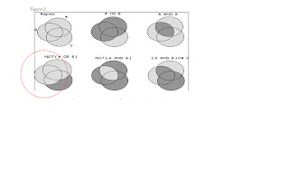
What is show in figure 2 is an example of a Boolean algebra where it uses the conditions OR, AND, and NOT to select feature. The example circled above shows a type of Boolean algebra using not A or B. Meaning that the system will not choose A or B only C.
3. What are the different types of spatial selection operations?
a. By Attributes
1. Set Algebra
2. Boolean Algebra
b. By Spatial characteristics
1. Adjacency
2. Containment
II. AFTER completing Ormsby Chapters 10 & 11, complete the following exercise.
§ Copy the Lab9a folder from Y:\courses_rmaas\Geog206\data to your working folder.
§ Open and explore the Lab9aData geodatabase.
4. Is there a feature dataset in the geodatabase? ___yes_________
5. What features classes are present? ___In the Los Angeles Data set we have three different feature classes. They are: PTDumeQuad, Vegetation and Wetlands. Within the personal geodatabase we have Wetlands_project._________________
Exercise 1: Prepare (simplify) a vegetation layer for the Los Angeles region for further spatial analysis.
6. How many features (records) exist in the Vegetation feature class in the Lab9aData.mdb geodatabase? __10896_____
§ To answer question 7, the vegetation layer needs to be simplified. Therefore, you need to dissolve the layer based on the “Covertype” field. The resulting output feature class should be saved into the Lab9aData geodatabase and named “VegCov”. You’ll need to find the Dissolve tool based on what you’ve learned in lecture/Ormsby thus far.
7. How many features (records) exist in the new VegCov feature class after running the dissolve operation? __9 records_____
§ The layer is still too large and unwieldy, so you need to clip it down to a smaller extent that only covers the Point Dume region. Use the PtDumeQuad feature class to do this. Name the output “VegCov_Clip” You’ll need to find the Clip tool based on what you’ve learned in lecture/Ormsby thus far.
8. How many features (records) exist in the new “VegCov_Clip” feature class? ____8______
III. Exercise 2: Generate a layer of Riverine wetlands that fall in the Point Dume quad.
§ Use the Select By Location tool to determine how many total wetlands have their centroid in the Point Dume quad.
9. How many wetland features (records) were selected? _404____
§ Save the selected features to a 'virtual'/temporary layer using the Selection|Create layer from selected features tool.
§ Using the new layer you created, query out wetlands where the system is equal to Riverine. (Hint: use the Systems field).
10. How many features (records) were selected? _123____
§ Export only these selected Riverine wetlands into a new shapefile named “Riverine_FirstInitialLastName”. Make sure to place this new shapefile inside your working directory for Lab 9a on C:/. Ex. Riverine_rmaas.
§ Capture a screenshot (Alt PrtScr) of your final Riverine layer and paste it into this document.
 |
| Riverine |
 |
| Riverine( Arc map screenshot) |


No comments:
Post a Comment